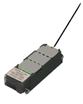
The Rainier-S20 is currently going through a complete design review. If you are interested in learning more or are interested in purchasing this tag, please contact us directly.
The Rainier-S20 is a solar-powered, GPS-equipped Argos transmitter (PTT) tag specifically designed for birds. The Rainier-S20 is suitable for birds weighing as little as 650 grams to be tracked with GPS precision and accuracy over land and sea for multiple seasons.

Overview
The Rainier-S20 has a very low profile and sports a powerful and flexible antenna, smooth surfaces, and rounded edges with no sharp/cutting finishes. The design helps minimize mass, drag, and risk of injury to the bird.
The deployed Rainier-S20 tags collects GPS locations on a flexible, customer-programmable deployment schedule. Over 6 ½ years of archived locations can be stored on the tag and transmitted via Argos satellites together with some diagnostic sensor data. The small, solid cast, 20-gram package is waterproof and tested to 100 meters depth.
The Rainier-S20 dispels all myths that a large bird requires a large tag. It’s a simple, smart, one-size-fits-all tag suitable for deployment on birds weighing 650 g or bigger. The tag can be fitted to a bird as supplied, or it can have any size footprint or padding glued to the base to lift the tag to fit larger species.
Key Features
Here are some of the key features of the Rainier-S20.
- Specific avian design—this tag is comfortable for the bird with rounded edges that allow for streamlined aerodynamics while preventing feather and skin damage from sharp cutting edges. During our field trials, all the birds we recaptured showed no evidence of any damage from the Rainier-S20.
- Argos antenna—our antenna is field-proven and virtually indestructible. The minimally intrusive, low-lying antenna exits the rear of the tag. It is lightweight, highly robust, and super flexible. The antenna is securely anchored in epoxy resin and withstands over 100 pounds of tensile force.
- Solar cells and power—solar-cell design and circuitry efficiencies allow for improved charging in low-light conditions and partial feather coverage.
- Smart algorithms differentiate shifts in day length and times of civil sunrise and sunset—Rainier-S20 tags’ smart day/night algorithms accurately calculate civil sunrise and civil sunset to the minute for any location on the globe. This, along with GPS, allows you to get data from locations all over the world with little to no gaps.
- External communications port with multiple benefits including:
- Administer your own tag setting through Wildlife Computers Tag Agent software
- Charge your tags indoors with visual LED feedback
- Download the entire tag archive if it is located after deployment (it does not need to come back to Wildlife Computers for data extraction)
- The portal advantage—Rainier-S20 tags are supported by the Wildlife Computers Data Portal, a collection of online data management tools and services. Developed specifically for the display and investigation of data from Wildlife Computers tags, the data portal streamlines the processes of acquiring, preserving, and sharing data services. The portal helps collect, prepare, and analyze the data returned from the tag—via Argos or the archive. Data are easily sorted, filtered, searched, uploaded, and shared. You can see a Google Earth display of your deployment track, color-coded to show the relative age of each location. You can also set up a live KMZ to get data into your own monitoring system.
User Guide
This user guide gives you all the essential information needed for interacting with, configuring, and deploying this tag.
USB Communications Cable Driver – 29-March 2023
Driver for the Wildlife Computers USB Communications cable.
Administer settings to your tag.
Specifications
Below are the physical specifications of the Rainier-S20.
| Dimensions(LxWxH) | 56 mm x 18 mm x 14 mm |
| Tag Weight (excluding neoprene) | 20 grams |
| Construction | Solid cast/hermetically sealed in biologically inert epoxy resin |
| Antenna | GPS patch antenna embedded. Argos antenna 200 mm. Protrudes from back edge of transmitter at 30° to the horizontal |
| Pressure Rating | Tested to 100 m depth |
| Memory/Archive | Approximately 58,000 GPS locations timestamped to the nearest second. Equates to > 6 years data stored at hourly locations 24/7 |
| Operating Frequency | 401.678 MHz |
| Operating Life | Solar tags >3 years |
| Sensors | GPS, temperature, battery voltage, |
| GPS Accuracy | Coordinate positions are recorded to four decimal places yielding accuracy to +/- 11 m |
| GPS Channels | 48 |
| GPS Datum | WGS84 |
| Operating Temperature Range | 0° C to 65° C |
| Communications | Via USB port and Tag Agent user interface software |
| Battery Charging | Solar or USB |
| Recovery Pinger | Optional in future designs, not currently activated |
| Battery | Lithium polymer rechargeable battery |
| RF Power Output | Maximum 500 mW, typically 200 mW when deployed |
| Tag On/Off Protocol | Using a magnet cover |
| Supply Voltage | 3.0 to 4.0 volts |
