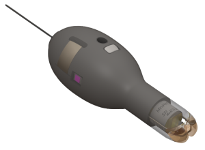
The MiniPAT is a pop-up archival transmitting tag (PAT tag, also known as a PSAT). It is a sophisticated combination of archival and Argos satellite technology. PAT tags are designed to track the large-scale movements and behavior of fish and other animals which do not spend enough time at the surface to allow the use of real-time Argos satellite tags.
Depth, temperature, and light-level data, among others, are collected and summarized for transmission and archived in onboard memory. Then on a preset date set by the researcher, the tag releases from its host animal, surfaces, and uploads a summary of the archived data to Argos satellites.
Developed with a focus on reliability, ruggedness, and ease of use, the MiniPAT features a stable low-drag shape, a strong integrated nosecone and pin, and a pinger for radio tracking recovery.
Our latest design offers the benefit of a more resilient nosecone and pin. The nose cone will no longer separate from the tag and will not stay with the tether after the pin burns to pop up. This design allows for much stronger retention and thereby increasing the probability of longer deployments.
Key Benefits of MiniPAT
- A complete record of depth, temperature, and light-level readings are stored. Should the MiniPAT be recovered, the full archive is available for download.
- Flexible programming allows researchers to customize and prioritize data transmissions and release parameters.
- A corrodible pin allows the release of the MiniPAT from the fish on a pre-programmed date or when certain conditions indicating the tag is no longer on the fish (conditional release) are met.
- Once released, the tag floats to the surface so data can be transmitted.
- The pinger allows for radio tracking recovery.
Data Products
- Depth Archive (Pressure)
- Temperature Archive
- Light Archive
- Acceleration Z-Axis Archive
- Acceleration 3-Axis Archive
- Upright and Knockdowns (Orientation) Archive
- Activity (ATS) Archive
- Dry Archive
- Light-Level Geolocation (GPE3)
- Argos Locations
- Daily Data—Depth, Temperature, and Light
- Orientation
- Activity Time Series (ATS)
- Depth Time Series
- Temperature Time Series
- Mixed Layer
- PDT
- Time-At-Temperature Histogram (TAT)
- Time-At-Depth Histogram (TAD)
User Guide/Software
This user guide gives you all the essential information needed for interacting with, configuring, and deploying this tag.
USB Communications Cable Driver – 29-March 2023
Driver for the Wildlife Computers USB Communications cable.
Administer settings to your tag.
A statistical model for estimating animal movements. GPE3 is an integrated component of the Wildlife Computers Data Portal and runs exclusively on our servers.
Specifications
Below are the physical specifications of the MiniPAT. A full description of the features is available on the downloadable MiniPAT Product Features (PDF).
| Attachment Type | Towed |
| Sensors | Wet/Dry, Depth, Temperature, Light, Accelerometer |
| Depth Sensor Range | 0-1700 m, 0-2000 m* |
| Depth Sensor Resolution | 0.5 m, 1 m* |
| Depth Sensor Accuracy | ±1% of reading |
| Temperature Sensor Range | -40° C to 60° C |
| Temperature sensor Resolution | 0.05° C |
| Temperature Sensor Accuracy | ±0.1° C |
| Conductivity Operational Limits | 0.1 to 5 S/m |
| Light Sensor | 5 x 10-12W.cm-2 to 5 x 10⁻²W.cm-2 |
| Operating Temperature Rating (°C) | -20° C to 50° C |
| Optimal Storage Temperature Range (°C) | 0° C to 5° C |
| Memory | 64 MB |
| Dimensions | 118 mm (length) x 41 mm (diameter) |
| Weight in Air | 68 g |
| Pressure Rating | 2000 m |
| Maximum Deployment Length | 730 days |
| 1Meters of freshwater. To convert to dBar, or an approximation for meters of seawater, multiply the reported balue by 0.9804 | |

