WildlifeComputers.com
+ 1 (425) 881 3048
8310 154th Avenue NE, Suite 150
Redmond, WA 98052 USA
WildlifeComputers.com
+ 1 (425) 881 3048
8310 154th Avenue NE, Suite 150
Redmond, WA 98052 USA

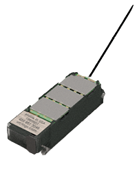
The Rainier-S20 tag from Wildlife Computers is a rechargeable, solar-powered GPS-equipped Argos transmitter (PTT) tag specifically designed for birds. The Rainier-S20 collects GPS locations and other sensor data on a highly flexible customer-programmable schedule during deployment. The archived data are stored locally as well as transmitted to the Argos satellite network. The Wildlife Computers cloud-based portal automatically downloads and processes the data and makes it available in near real time.
The tag’s intelligent, low-power design incorporates our latest Argos-certified transmitter, a 48-channel GPS receiver, temperature, battery voltage, tilt, and accelerometer sensors. A non-volatile memory with the capacity to store up to 58,000 locations (about 6.5 years of GPS locations based on one location per hour). The small, solid cast 20-gram package is waterproof and tested to 100 meters depth.
It’s a simple, smart, one-size-fits-all approach, field tested and suitable for deployment on birds weighing 650 g and above. In its simplest form, it can be fitted to a bird as supplied, or it can have any size footprint or padding glued to the base to lift the tag to fit larger species as desired.
Specific avian design—the “smaller is better” approach to design means there is no need for a bigger tag on a bigger bird. The rounded edges of the tag allow for streamlined aerodynamics while preventing any bird damage from sharp cutting finishes. We also offer either harness loops or holes for attachment depending on your preference.
Argos antenna—minimally intrusive, low-lying antenna exiting the rear of the tag is lightweight, highly robust yet super flexible. The antenna is securely anchored in epoxy resin and withstands over 100 pounds of tensile force ensuring it will stand up to abuse from birds.
Solar cells and power—solar cell design and circuitry efficiencies allow for improved charging in low-light conditions and partial feather coverage.
Flexible calendar scheduling—hundreds of duty cycles if required, not limited to just five.
Smart algorithms differentiate shifts in day length and times of civil sunrise and sunset—Rainier-S20 tags’ smart day/night algorithms accurately calculate civil sunrise and civil sunset to the minute for any location on the globe. The algorithms are integrated within the scheduling and automatically and dynamically control the scheduling which is particularly impressive on migratory birds crossing multiple time zones or on resident birds as the seasons change.
External communications port with multiple benefits including:
Transmitted locations and status messages—the Rainier-S20 methods of sending GPS locations and other data through Argos builds on Wildlife Computers more than 20 years of experience of sending information via satellite in the most challenging marine environments and timestamps each to within two minutes of the actual fix. Status messages and cumulative status data sent can be used to infer the basic health of the tag.
Technical Specifications
| Tag weight (excluding neoprene) | 20 grams |
| Dimensions (L x W x H) mm | 56 x 18 x 14 |
| Construction | Solid cast/hermetically sealed in biologically inert epoxy resin |
| Antenna make and length | GPS patch antenna embedded. Argos antenna 200 mm. Protrudes from back edge of transmitter at 30° to the horizontal |
| Pressure rating | Approximately 58,000 GPS locations timestamped to the nearest second |
| Memory/archive | Approximately 58,000 GPS locations timestamped to the nearest second |
| Operating frequency | 401.678 MHz |
| Operating life | Solar tags > 3 years |
| Sensors | GPS, temperature, battery voltage, accelerometer, tilt |
| GPS accuracy | Coordinate positions are recorded to four decimal places yielding accuracy to +/- 11 m |
| GPS channels | 48 |
| GSP datum | WGS84 |
| Operating temperature range | Range: 0° C to 65° C as specified by battery manufacturer |
| Communications | Via USB port and Tag Agent user interface software |
| Battery charging | Solar or USB |
| Recovery pinger | Optional in future designs, not currently activated |
| Battery | Lithium polymer rechargeable battery |
| RF power output | Maximum 500 mW, typically 200 mW when deployed |
| Tag on/off protocol | Using a magnet cover |
| Supply voltage | 3.0 to 4.0 volts |