SPOT tags are highly versatile, cost-effective satellite transmitting tags designed for tracking horizontal movements of free-ranging marine animals.
Overview
When at the surface, SPOT tags send out short transmissions to the Argos satellite system. Consecutive transmissions received in a single satellite pass are used to calculate the location of the transmitter. Locations are available in near-real-time with accuracies as high as 250 meters. Global coverage by the Argos system allows animals to be tracked over long distances and in remote areas. Wildlife Computers SPOT tags are widely used and are one of the most published-on marine satellite tracking tags on the market.
A SPOT tag works best for marine animals that routinely spend time at the surface like sharks, albatross, penguins, sea turtles, pinnipeds, and cetaceans.
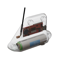
SPOT tags come in a variety of shapes and sizes for a variety of attachments. We have, or can create, a solution that works best for your research animal.
Key Features Available in SPOT Configurations
- Specialized Shapes and Attachments—the biggest differentiator of our SPOT tags is the variety of shapes and sizes—over 50 different configurations. There are a variety of attachment options including back mount, fin mount, flipper mount, float mount, AUV mount, towed, transdermal, and anchored.
- Recovery Pinger—SPOT tags are equipped with a UHF pinger. This optional pinger can be enabled to send out low-power, unmodulated “pings” while the tag is at the surface. Tags and animals can then be located and actively tracked using a directional antenna and receiver.
- Highly Customizable Data Collection and Transmitting Schedule—researchers can customize and prioritize data transmissions to capture the information that is most important for the project. Deployments can be tailored to address unique experimental objectives. Flexible transmission schedules provide the ability to extend the life of the tag by focusing on specific seasons or times of the year and optimizing transmissions for when satellites are in view.
- The Portal Advantage—SPOT tags are supported by the Wildlife Computers Data Portal, a collection of data management tools and services. Developed specifically for the display and investigation of data from Wildlife Computers tags, the data portal streamlines the processes of acquiring, preserving, and sharing data. The portal has tools to program the tags and collect, prepare, analyze, and present the data returned via Argos. Data are easily sorted, filtered, searched, mapped, and shared. You can see a live map of your tracks, with positions color-coded by the time since deployment. You can also set up a live KMZ to view your data in your own visualization browser.
Data Products
- Argos Locations
- Time-At-Temperature Histogram (TAT)
- Percent-Dry Timeline
Specifications
Below are the physical specifications of the SPOT. Numerous shapes are available with the same feature-set technology.
| Sensors | Temperature, Wet/Dry |
| Pressure Rating (m) | 2000 meters for most shapes |
| Operating Frequency | 401.678 MHz |
| Temperature Sensor Range | -40° C to 60° C |
| Temperature Sensor Resolution | 0.05° C |
| Optimal Storage Temperature Range | 0° C to 5° C |
| Conductivity (Wet/Dry) Operational Limits | 0.1 to 5 S/m* |
| Length (mm), Diameter (mm), Weight (g) | ** |
| Maximum Deployment Length | ** |
* Conductivity Operational Limits can be customized for freshwater applications. Please contact Wildlife Computers to
learn more.
** Specification is dependent upon the configuration model. You can see different SPOT configurations here.
For more information, visit our website at www. wildlifecomputers.com, send an email to tags@ wildlifecomputers.com, or call (425) 881-3048.
Tag features and specifications subject to change without notice
Antenna length not to scale