13 Jul Project Kingfish
Posted at 16:13h in Newsletter
 Project Kingfish recently had its first successful Sydney satellite tag deployment. How does their program work?
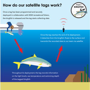
- First, a kingfish is caught. Then the satellite tag is secured into the muscle of the kingfish, anchoring the dart between the pterygiophores (fin bones) much like an NSW DPI Game Fish tag.
- When the kingfish is released and the tag comes into contact with seawater, it begins recording information. As programmed, every six seconds the tag will record a range of different parameters such as light level, swimming depth, sea temperature, and activity levels over the deployment period.
- The tag will then detach at a pre-programmed date (or prematurely if the tag is pulled out of the fish), float to the surface, and begin to transmit data to our team via a constellation of satellites passing over our heads. With each transmission over the next few days, the tag will send our team a summarized (low resolution, for example, every 12h period) dataset of what the tagged kingfish did. If we physically retrieve the tag, we can access the full high-resolution dataset (every 6 seconds) and get much more detailed behavioral information.
- However, once we get the data, it’s not as easy as just plugging some GPS coordinates in and visualizing the track. The data come encoded and need to undergo rigorous quality control. Then, through a process called ‘light-based geolocation’, which essentially uses the light levels measured by the tag as well as known dusk and dawn times in the region, sea surface temperatures and known seafloor depth, complex statistical models are built to estimate the most likely movement track for the tagged fish.
Work has now begun on reconstructing the track of the first full kingfish track and the project will share results soon.
https://www.facebook.com/ProjectKingfish/photos/a.106194961966819/156646903588291/